Spain braces for more: Eleven regions with storm warnings
By Molly Grace • Published: 30 Jan 2026 • 20:18 • 3 minutes read
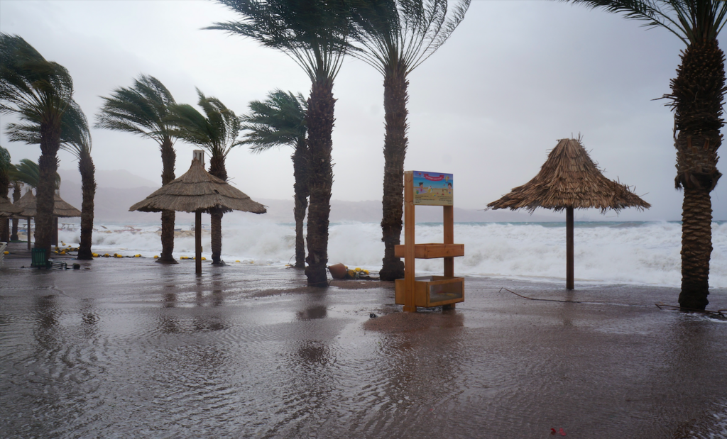
The combination of strong winds and elevated seas raises the risk of coastal flooding. Photo credit: Bakusova/Shutterstock
Spain is experiencing another weekend of unstable winter weather, with only a short pause in rainfall in some areas. The State Meteorological Agency (AEMET) has issued multiple alerts as strong winds, snow, and rough seas continue to affect large parts of the country. Eleven autonomous communities are on warning, with Galicia facing the most extreme coastal conditions.
Following the passage of six high-impact storms in January, much of the country has seen prolonged cloudy and rainy conditions, limiting sunlight. Although rainfall may ease temporarily, meteorologists warn that dangerous conditions will persist, including gusty winds, snowfall at higher elevations, and hazardous waves along the coasts.
Strong Wind Alerts Across Regions
AEMET has placed Andalucía, the Balearic Islands, Castilla-La Mancha, Catalonia, and the Valencian Community under orange wind warnings, with gusts expected to reach 90–100 km/h. Meanwhile, Aragon, Cantabria, Castilla y León, Madrid, Murcia, the Basque Country, and Melilla are under yellow alerts, with wind speeds anticipated between 70–80 km/h. Residents are being advised to secure loose objects, limit outdoor activities, and take precautions during travel.
Snow and Frost in Elevated Areas
Snowfall warnings cover Aragon, Castilla y León, Catalonia, Galicia, Madrid, and Navarra. In northern and mountainous regions, snow is expected at altitudes of 700–1,000 metres, with accumulations higher in the upper slopes. By the end of the day, snow levels are forecast to rise to 1,200–1,400 metres. Even the Balearic Islands may see snow in the higher zones of Mallorca.
Frost is expected in mountainous areas of northern Spain, with moderate frost in the Pyrenees. These conditions are expected to make travel in elevated regions hazardous, particularly for vehicles unprepared for snow and ice.
Rainfall and Thunderstorms
Rain is anticipated in much of the northern third of Spain, where it could be accompanied by isolated thunderstorms and small hail. Mountainous zones in the southeast, Spain’s central plateau and northern Balearic Islands may also see localised precipitation. The highest rainfall totals are expected in the eastern Cantabrian region, western Pyrenees, and eastern Bética ( Granada and Almería mountain range).
In the Balearic Islands, storms may occur in southern parts during the early hours, creating temporary hazards for outdoor activity. Overall, rainfall will be less intense than earlier in the week, but localised showers may still cause disruption.
Coastal and Maritime Hazards
Coastal regions and the autonomous city of Ceuta are under alerts for high seas and dangerous waves. Galicia is under a red alert during the early morning hours, with waves potentially reaching nine metres, before the warning lowers to orange for the remainder of the day. Other northern and western coasts remain on yellow alerts, while civil protection authorities urge residents to avoid beaches, docks, and exposed coastal areas.
The combination of strong winds and elevated seas raises the risk of coastal flooding, fallen debris, and damage to public infrastructure. Maritime and fishing activities have been temporarily restricted in affected regions to protect personnel and vessels.
Regional Impacts and Safety Measures
Authorities across the country are taking precautions. In Galicia, emergency services report fallen trees, localised flooding, and transport disruptions. The Balearic Islands have temporarily closed outdoor facilities, particularly in areas exposed to storms.
In mainland areas under orange wind warnings, such as Valencia, Catalonia, and Castilla-La Mancha, local councils have suspended open-air events and sporting activities, while civil protection agencies remain on high alert. Residents are advised to follow AEMET updates, avoid unnecessary travel during periods of high wind, and exercise caution on roads and elevated terrain.
Outlook for the Weekend
Weather models suggest that while rain may remain intermittent, strong wind gusts, snow in elevated areas, and rough seas will continue through Saturday and into the weekend. The current pattern, driven by successive Atlantic low-pressure systems, means that hazardous conditions are likely to persist, especially in Galicia, northern mountain ranges, and exposed coastal zones.
AEMET emphasises the importance of staying informed through official alerts and taking precautions against falling trees, flooding, icy roads, and coastal waves. With multiple regions affected simultaneously, this weekend represents a continuation of one of the most severe winter weather periods in Spain this season.
Follow Euro Weekly News on Google News
Get breaking news from Spain, travel updates, and expat stories directly on your Google News feed.
Follow on Google NewsSign up for personalised news
Subscribe to our Euro Weekly News alerts to get the latest stories into your inbox!
By signing up, you will create a Euro Weekly News account if you don't already have one. Review our Privacy Policy for more information about our privacy practices.


Molly Grace
Molly is a British journalist and author who has lived in Spain for over 25 years. With a background in animal welfare, equestrian science, and veterinary nursing, she brings curiosity, humour, and a sharp investigative eye to her work. At Euro Weekly News, Molly explores the intersections of nature, culture, and community - drawing on her deep local knowledge and passion for stories that reflect life in Spain from the ground up.
Comments
Lee
01 February 2026 • 10:32weather modification
Comments are closed.