Spain weather alert: storms, heavy rain and strong winds hit multiple regions this week
By Farah Mokrani • Published: 08 Apr 2026 • 12:12 • 3 minutes read
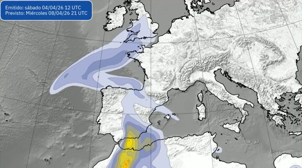
Aemet map shows storm system bringing rain and instability across Spain Credit : X- Aemet
A sharp change in weather is set to affect large parts of Spain this week, with heavy rain, thunderstorms, strong winds and rough seas expected across several regions. Spain’s state weather agency Aemet has issued warnings in seven communities, mainly in the west and southwest, where conditions are likely to be at their worst.
The shift is being driven by a low pressure system sitting to the southwest of the Iberian Peninsula, which is expected to remain in place and continue feeding unstable weather into the country. For many areas, especially inland, this means persistent rain, sudden storms and a noticeable drop in temperatures.
Where storms and heavy rain will hit Spain hardest
The most affected areas are expected to be in the western half of the country, particularly Andalucía, Extremadura, Castilla y León and Galicia. Rainfall in these regions could exceed 15 litres per square metre in just one hour, with storms developing alongside.
Storm warnings have been issued in provinces including Córdoba, Málaga and Sevilla, as well as parts of Asturias, León, Zamora, Ciudad Real, Toledo, Badajoz, Cáceres, Lugo and Ourense. In some of these areas, conditions could change quickly, with intense bursts of rain and thunder.
Wind is another concern, especially across the southern plateau, where gusts could exceed 70 kilometres per hour in isolated areas. Meanwhile, coastal regions such as A Coruña, Pontevedra and parts of the Canary Islands are under alerts for rough seas.
Although the heaviest rain is expected in the west, the system may extend further into central Spain, bringing unsettled conditions to nearby regions as well.
Mud rain, calima and falling temperatures in parts of Spain
Alongside the rain, another factor to watch is dust in the air. Aemet has warned of suspended dust affecting central and western Spain, which could lead to muddy rain when it mixes with precipitation.
This type of rain, often seen during episodes of calima, can leave a visible residue on cars, windows and outdoor surfaces. It is not unusual in Spain, but it tends to catch people off guard when it arrives alongside storms.
Temperatures are also expected to drop across much of the centre and west of the country. The decrease could be quite noticeable in regions such as Andalucía and Extremadura, particularly during the daytime.
At the same time, eastern areas and the Balearic Islands may see slightly higher temperatures, especially overnight, creating a clear contrast between different parts of the country.
Fog and low visibility could also affect some coastal areas in the northern Mediterranean and the Balearics, while mist may form in higher inland areas.
What to expect in the coming days across Spain
The unsettled weather is not expected to clear quickly. Because the low pressure system is likely to remain in place, rain could continue over several days, especially in the southwest.
In the rest of mainland Spain and the Balearic Islands, skies are expected to remain cloudy, with periods of high and medium cloud rather than constant rain. Conditions will feel more changeable than in recent days.
In the Canary Islands, the picture is slightly different. Northern parts of the more mountainous islands are expected to see cloudy skies with light rain, along with a drop in daytime temperatures. Winds from the north are likely to strengthen and gradually shift towards the northwest.
Across the mainland, winds will generally come from the south and west, ranging from light to moderate, but with the potential for stronger gusts in exposed areas.
A midweek shift that could catch many off guard
After a period of more settled weather in some regions, this change may come as a surprise. The mix of heavy rain, storms, wind and dust in the air creates conditions that can feel quite unstable, even within the same day.
For residents and travellers, the key is to stay aware of local forecasts, especially in areas under official warnings. Sudden downpours and storms can develop quickly, particularly inland.
While not every region will see the same level of impact, the overall picture is clear. Spain is heading into a few days of unsettled weather, with the west and southwest firmly in the spotlight.
Sign up for personalised news
Subscribe to our Euro Weekly News alerts to get the latest stories into your inbox!
By signing up, you will create a Euro Weekly News account if you don't already have one. Review our Privacy Policy for more information about our privacy practices.


Farah Mokrani
Farah is a journalist and content writer with over a decade of experience in both digital and print media. Originally from Tunisia and now based in Spain, she has covered current affairs, investigative reports, and long-form features for a range of international publications. At Euro Weekly News, Farah brings a global perspective to her reporting, contributing news and analysis informed by her editorial background and passion for clear, accurate storytelling.
Comments
Lee
09 April 2026 • 09:39its veen crap since christmas, stop messing with the weather. i have a video of me firing up the jacuzzi this exact time last year
Comments are closed.