Spain faces intense weekend storms and cooler air moves in and government warns of storms, hail and wind
By Adam Woodward • Published: 14 Aug 2026 • 10:28 • 3 minutes read
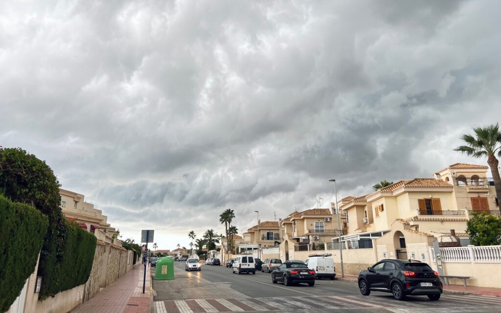
Storm clouds gather over Alicante. Credit: Marinissim - Shutterstock
Spain’s seemingly never-ending hot spell is set for a sharp break this weekend. A DANA low pressure area is forming from an Atlantic trough and is expected to drive widespread showers and thunderstorms across much of the country, with effects reaching the Balearics and eastern zones.
Saturday looks like the peak day for both storm intensity and the notable temperature drop, according to AEMET, the official weather service, and Civil Protection guidance issued on August 14.
Hot, dry subtropical air is giving way to cooler Atlantic flow. Models point to organised storm cells capable of dumping 30-40 litres per square metre in an hour in the worst spots, with hail over 2 cm possible and gusts that could reach 80 to 90 km/h. Flash-flood risks are rising in dry riverbeds and steep terrain after weeks of heat. Travellers moving around the country this weekend should factor in these changes.
Friday, August 14: storms build while heat continues
Instability ramps up this afternoon. Early storm centres are expected to appear from around 2pm, strongest where Aragon, Castilla-La Mancha and the Comunidad Valenciana meet. Local totals could exceed 60 litres in under three hours, raising the chance of sudden flash flooding. Similar heavy showers are likely over eastern Andalusian sierras, inland Murcia and parts of the Valencian Community, Castilla-La Mancha and Aragon. Further north and east, activity extends into La Rioja, eastern Castilla y Leon, Catalonia and Navarra.
Hail bigger than 2 cm is probable across the eastern interior half of the peninsula; isolated larger stones cannot be ruled out. Strong wind gusts and the odd downburst add to the risk of material damage. Orange warnings cover heavy rain rates in interior Valencia, Gudar-Maestrazgo, Albarracin-Jiloca and the Serrania de Cuenca. Yellow alerts for storms stretch across much of the eastern and northern areas of the country. Heat warnings are still active in many regions even as the cooler air begins to edge in from the northwest and centre.
Coastal stretches will stay warmer and more settled for longer, yet inland hills near Granada, Almeria and Murcia already carry serious storm potential. Anyone on the road should slow down near watercourses and avoid parking in low-lying spots.
Saturday, August 15: peak day for storms and the temperature plunge
Saturday is expected to be the most active day of the episode. With the low pressure sitting over the peninsula, showers and thunderstorms become quite general across the interior, less so in the far southwest and Galicia, and they will also affect the Balearics. Intensity is generally strong and locally very strong, though exact locations remain hard to pin down hours ahead. Large hail remains on the cards.
#ElTiempo
🌡️ Bajan las temperaturas en el centro y norte de la Península, así como en zonas de los dos archipiélagos.⛈️ Esta tarde se esperan tormentas intensas en el norte y este peninsular: dejarán algunos fenómenos adversos.
🔗 https://t.co/i9nUKz0Ok8 pic.twitter.com/tza2dmek19
— Meteored España (@MeteoredES) August 14, 2026
Temperatures are due to fall notably, moving closer to seasonal normals after the recent extremes. AEMET has warnings active across 14 autonomous communities for rain and storms, including Andalucia, Aragon, the Balearics, Castilla-La Mancha, Catalonia, Madrid, Murcia, Navarra and the Comunidad Valenciana. Residual heat alerts still cover parts of the Balearics, Catalonia and Galicia.
14/08 08:55 AVISOS HOY Y MAÑANA | Comunitat Valenciana: lluvias, temperaturas máximas y tormentas. Nivel máximo de aviso: naranja.
Actualizaciones en https://t.co/R3Fs2JzKgr pic.twitter.com/2u61F6xrs1— AEMET Comunitat Valenciana (@AEMET_CValencia) August 14, 2026
Readers based on the Costa del Sol, Costa Blanca or in Almeria and Murcia should watch for afternoon build-ups that could drift seaward or produce sudden strong gusts. Inland Granada and Murcia valleys look more exposed. Island visitors face a similar risk of storm cells. Keep an eye on local updates, as storm tracks can change quickly.
ACTUALIZACIÓN AVISOS DE FENÓMENOS METEOROLÓGICOS ADVERSOS POR LLUVIAS-TORMENTAS-TEMPERATURAS MÁXIMAS PARA HOY, VIERNES 14 DE AGOSTO, EMITIDOS POR LA AEMET
🟡 Nivel amarillo – Lluvias: hasta 15 l/m² en una hora en el Altiplano, Noroeste, Vega del Segura, Valle de Guadalentín,… pic.twitter.com/fOkqEDg1vs
— 112 Región de Murcia (@112rmurcia) August 14, 2026
Sunday, August 16 and beyond: instability eases but risks continue
Sunday still brings showers and thunderstorms over large areas of Spain, though the overall coverage and intensity will begin to ease compared with Saturday. The Balearics remain in the frame as temperatures stay lower than recent days. From Monday, August 17, the uncertainty grows around the DANA’s exact path, but the chance of widespread storms drops clearly, and values start to recover without returning straight to the previous highs.
Anyone planning trips this weekend across Spain, whether heading north from the costas or island-hopping, should allow extra time and check the latest AEMET maps and local alerts before setting off. Official updates remain available on the AEMET website and the national Civil Protection network.
Follow Euro Weekly News on Google News
Get breaking news from Spain, travel updates, and expat stories directly on your Google News feed.
Follow on Google NewsSign up for personalised news
Subscribe to our Euro Weekly News alerts to get the latest stories into your inbox!
By signing up, you will create a Euro Weekly News account if you don't already have one. Review our Privacy Policy for more information about our privacy practices.


Adam Woodward
Adam is a writer who has lived in Spain for over 25 years. With a background in English teaching and a passion for music, food, and the arts, he brings a rich personal perspective to his work at Euro Weekly News. As a father of three with deep roots in Spanish life, Adam writes engaging stories that explore culture, lifestyle, and the everyday experiences that shape communities across Spain.
Comments