Storm Marta moves in as flood-hit Spain faces another tough weekend
By Farah Mokrani • Published: 07 Feb 2026 • 11:55 • 3 minutes read
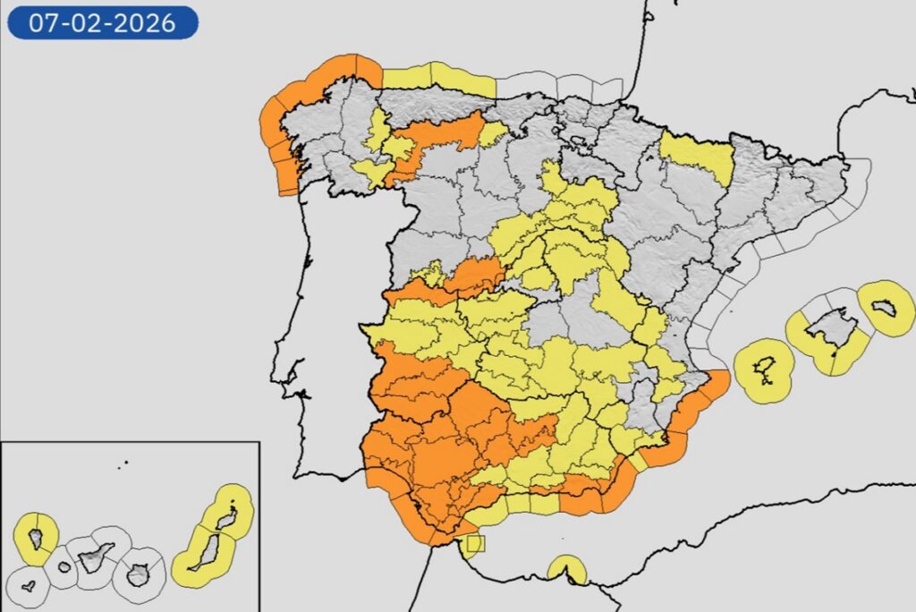
Storm Marta triggers widespread weather alerts across Spain, with heavy rain, snow and strong winds affecting large areas. Credit : X - Aemet
Spain isn’t getting a break from the weather. Just as Storm Leonardo starts to fade, a new system – Storm Marta – is already rolling in from the Atlantic, and it’s arriving at a bad moment.
Large parts of the country are still dealing with saturated ground, swollen rivers and lingering disruption. Marta’s arrival means more heavy rain, fresh snowfall and strong winds, raising fresh concerns in areas that have already taken a battering this week.
Leonardo bows out, but the rain didn’t
Friday turned into a messy transition day. Leonardo was already on its way out, but it still carried enough energy to keep conditions unsettled across much of the peninsula. Rain continued to move from west to east, affecting wide areas and falling heaviest in Galicia, Extremadura and western Andalusia.
In the southwest, showers occasionally intensified, bringing a risk of isolated storms and hail. Snow appeared at higher elevations in the north and centre, particularly across the Cantabrian Mountains, while the Pyrenees saw snowfall later in the day.
The main concern, however, was accumulation. After days of persistent rainfall, the ground in many regions was already saturated and unable to absorb much more water. That left several areas vulnerable to flooding, even where rainfall totals were lower than earlier in the week.
Storm Marta brings heavier rain, lower snow levels and stronger winds
Conditions worsen overnight into Saturday, February 7 as Storm Marta takes control. Rain becomes more widespread and more persistent, especially across Extremadura, Castilla y León, Galicia, Andalusia, Castilla-La Mancha and the Madrid region.
At the same time, colder air moves in, pushing snow levels down to around 900 to 1,000 metres in many areas. That opens the door to significant snowfall not just in mountain ranges, but also in nearby high-lying zones.
Forecasts point to notable snow accumulations in the Cantabrian range, the Central System, Sanabria, the Iberian System, the Pyrenees and Sierra Nevada. Central and northern Spain look particularly exposed, while parts of the southeast could also see snow later in the day, though generally at higher elevations.
Andalusia remains a major concern. Provinces such as Cádiz, Málaga, Granada and Almería are expected to see prolonged rainfall, with some intense bursts. In places like Grazalema, where the ground is already waterlogged, even moderate rain could lead to run-off and local flooding.
Wind and rough seas add another layer of risk
Rain and snow aren’t the only problems. Strong winds are forecast across much of southern Spain, the eastern coastline and the Balearic Islands. In exposed areas – particularly around the Strait of Gibraltar and the Cádiz coast – gusts could exceed 90 to 100 km/h.
At sea, conditions are expected to deteriorate sharply. Both the Atlantic and Mediterranean coasts face rough seas, with waves of five to seven metres possible along parts of the Galician and Andalusian shoreline.
By Sunday, February 8 Marta begins to drift northeast, and conditions slowly start to settle. Even then, rain is likely to linger in the north, inland regions, Andalusia, Catalonia and the Balearics, while snow continues in mountainous areas before easing later in the day.
Any improvement may be short-lived. Forecasters are already watching another Atlantic front expected to arrive later on Sunday, potentially bringing fresh rain to the west and snow inland.
Warnings remain in place nationwide
Weather alerts remain widespread. Orange warnings are active in parts of Andalusia, Extremadura and Castilla y León for heavy rainfall, with totals reaching 80 litres in 12 hours in some areas. Other orange alerts cover heavy snowfall and high winds, particularly in exposed southern zones.
Alongside these, yellow warnings for rain, snow, wind, storms and coastal conditions extend across much of the country.
For many communities, this weekend isn’t about preparing for bad weather – it’s about coping with more of it. With the ground already saturated and emergency services stretched, Storm Marta arrives at a time when Spain can least afford another hit.
Stay tuned with Euro Weekly News for more news from Spain
Sign up for personalised news
Subscribe to our Euro Weekly News alerts to get the latest stories into your inbox!
By signing up, you will create a Euro Weekly News account if you don't already have one. Review our Privacy Policy for more information about our privacy practices.


Farah Mokrani
Farah is a journalist and content writer with over a decade of experience in both digital and print media. Originally from Tunisia and now based in Spain, she has covered current affairs, investigative reports, and long-form features for a range of international publications. At Euro Weekly News, Farah brings a global perspective to her reporting, contributing news and analysis informed by her editorial background and passion for clear, accurate storytelling.
Comments
Michael
08 February 2026 • 13:12Hi, I keep seeing the weather is bad is southern Spain but I don’t see Orihuela Costa mentioned, how far south is the bad weather going, whilst I feel for the people who are experiencing the bad weather and storms I would like an update on the area we have our apartment as well if you have any news, best wishes to all affected by these storms.
Adam Woodward
08 February 2026 • 13:16Mostly in the west at the moment. Moving East, but dissipating by the time it gets to the East Coast.
Comments are closed.