UN warns ‘Super El Niño’ could push global weather to dangerous extremes
By Farah Mokrani • Published: 20 Jul 2026 • 19:22 • 3 minutes read
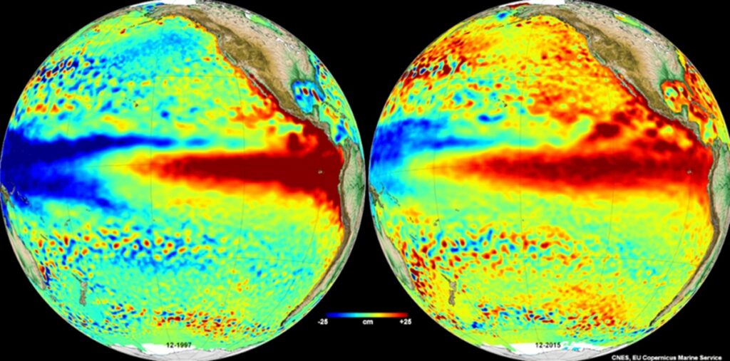
Satellite data compares two major El Niño events across the Pacific Ocean. Credit : www.atmosfera.unam.mx
A powerful El Niño is gathering strength in the Pacific, and scientists say it could have consequences far beyond the ocean where it begins. The United Nations’ World Meteorological Organization (WMO) and the US National Oceanic and Atmospheric Administration (NOAA) are warning that the climate pattern is becoming increasingly likely to reach exceptional intensity before the end of 2026. According to NOAA’s latest forecast, there is now an 81 per cent chance that this event will become unusually strong.
For most people, El Niño sounds like a distant weather phenomenon with little impact on everyday life. In reality, it has the potential to reshape weather patterns across much of the world. Previous powerful events have brought severe droughts, destructive flooding, record breaking temperatures and widespread disruption to agriculture. Scientists believe the current event could do the same if it continues to develop as expected.
It also arrives at a time when global temperatures are already running unusually high. Researchers say that combination is why there is growing concern that 2026 could become one of the hottest years ever recorded, with the effects continuing well into 2027.
Why scientists are becoming increasingly concerned
El Niño is part of a natural climate cycle known as the El Niño Southern Oscillation, or ENSO.
Under normal conditions, trade winds push warm surface water across the Pacific Ocean towards Indonesia and Australia. Those winds help maintain weather patterns that influence rainfall and temperatures around the globe.
When the winds weaken, the balance changes.
Warm water begins moving back towards the eastern Pacific, closer to South America. That shift releases additional heat into the atmosphere and alters rainfall patterns across large parts of the planet.
According to NOAA, measurements taken from satellites and ocean monitoring buoys already show sea surface temperatures in parts of the eastern equatorial Pacific reaching anomalies of up to 2.7°C above normal.
The WMO has also confirmed that the event has strengthened rapidly in recent months.
Although El Niño is a naturally occurring phenomenon, scientists explain that it is now developing against the backdrop of a warming climate. That means the extra heat released from the Pacific is being added to temperatures that are already higher than they were decades ago.
The result is a greater likelihood of record breaking global temperatures.
That does not automatically mean every country will experience extreme weather in exactly the same way. In fact, one of El Niño’s defining features is that its effects vary dramatically depending on where you are.
Some parts of the world could become much drier while others prepare for flooding
One reason meteorologists pay such close attention to El Niño is that it rarely produces the same outcome everywhere.
Forecast models currently suggest that Indonesia, much of Southeast Asia and parts of Central America could experience significantly lower rainfall if the event strengthens further.
Long periods without rain can put pressure on reservoirs, affect food production and increase the likelihood of large wildfires as forests and vegetation become increasingly dry.
Meanwhile, countries on the opposite side of the Pacific may face the opposite problem.
Along the west coast of South America, particularly Peru, authorities are already preparing for the possibility of exceptionally heavy rainfall after declaring a state of emergency.
Southern parts of the United States could also experience wetter than normal conditions, with an increased risk of flooding and coastal storm impacts.
Although Europe is not expected to experience the dramatic changes seen around the Pacific basin, global weather systems are interconnected. Large El Niño events have historically influenced temperatures and rainfall patterns well beyond the regions where the phenomenon develops.
For that reason, climate experts across Europe will also be watching the Pacific closely during the coming months.
What happens next depends on how the Pacific evolves
Despite the growing confidence in forecasts, scientists stress that El Niño is still developing.
The 81 per cent probability published by NOAA reflects the likelihood of the event reaching exceptional strength before the end of 2026. It does not mean every predicted impact will occur exactly as forecast.
Weather systems remain complex, and local conditions can still influence how individual regions are affected.
Even so, international organisations believe the latest forecasts are strong enough to justify early planning.
Governments responsible for water supplies, agriculture, emergency services and critical infrastructure are expected to monitor developments closely as the year progresses.
El Niño itself is not unusual. It has occurred many times before. What makes this episode different is the possibility that it could become one of the strongest in years while global temperatures are already running at exceptionally high levels.
Over the coming months, scientists will continue analysing satellite observations, ocean temperatures and atmospheric conditions to see whether current forecasts prove accurate.
If they do, the weather experienced in many parts of the world during 2026 and into 2027 could look very different from what people have come to expect. That is why the latest warnings from the WMO and NOAA are attracting so much attention long before the event reaches its expected peak.
Follow Euro Weekly News on Google News
Get breaking news from Spain, travel updates, and expat stories directly on your Google News feed.
Follow on Google NewsSign up for personalised news
Subscribe to our Euro Weekly News alerts to get the latest stories into your inbox!
By signing up, you will create a Euro Weekly News account if you don't already have one. Review our Privacy Policy for more information about our privacy practices.





Farah Mokrani
Farah is a journalist and content writer with over a decade of experience in both digital and print media. Originally from Tunisia and now based in Spain, she has covered current affairs, investigative reports, and long-form features for a range of international publications. At Euro Weekly News, Farah brings a global perspective to her reporting, contributing news and analysis informed by her editorial background and passion for clear, accurate storytelling.
Comments