Apple Maps’ camera backpacks are walking Spain’s streets – and the images may train AI
By Harry Dennis • Published: 05 Aug 2026 • 23:09 • 3 minutes read
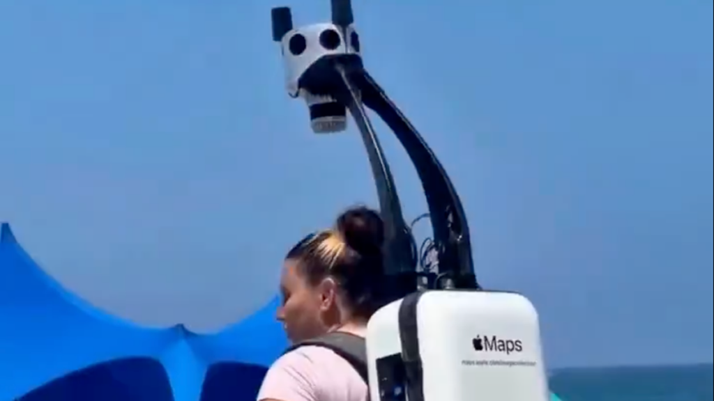
Apple uses portable camera systems to map pedestrian areas its vehicles cannot reach. Credit: nifunifa712 / X
Apple has taken its street-mapping cameras beyond the road, sending backpack-equipped surveyors through pedestrian areas of Madrid and Cataluña. While faces and number plates are blurred before publication, homes are obscured only if a person requests it, and anonymised images may also be used to train AI.
Apple’s cameras are reaching places its vehicles cannot
Apple conducted backpack surveys in Cataluña from March 30 to June 23, 2026, and in the Community of Madrid until July 1, according to the company’s official image-collection schedule. The portable systems allow surveyors to photograph pedestrianised streets, squares, pathways and other public spaces that cannot be reached by Apple’s mapping vehicles. Apple specifically cites streets in Madrid where driving is not possible as an example of where the backpacks can come in handy.
Some of the information collected can be used directly in Apple Maps, including its Look Around feature, which allows users to explore streets through a panoramic ground-level view. Other portable surveys use iPhones, iPads or similar devices to improve the accuracy of the underlying map.
A video circulating on X has now placed the equipment under renewed scrutiny. It shows an Apple Maps operator carrying one of the distinctive camera backpacks through a busy public area near the coast.
https://twitter.com/NifuNifa712/status/2084700899013013738?s=20
The footage does not establish that Apple has introduced an entirely new mapping system, nor is it evidence of a privacy breach. But it does raise questions on what happens to the images of people, vehicles and homes caught along the way, and whether some places should remain “best kept secrets”.
Faces and number plates are blurred before publication
Apple says it blurs faces and vehicle registration plates in images published through Look Around. The same privacy protections apply whether the imagery was collected from a vehicle or by a surveyor walking with portable equipment. Apple promises that identifying details will be obscured in the publicly available imagery.
Spain’s Data Protection Agency says registration plates can constitute personal data, therefore blurring plates removes one of the clearest identifying details before a street scene is made available online. Homes, however, are treated differently. Apple does not promise to blur house façades automatically, although residents can request that their own individual property be obscured. Requests can also be submitted if a face or registration plate has not been sufficiently hidden. This places some responsibility on residents to inspect the published imagery and complain if they believe it reveals more than they are comfortable having online.
The imagery can serve a second purpose beyond Maps
The most significant privacy question is how the resulting material may later be reused, and not just on their maps app. Apple says blurred imagery collected during its mapping surveys can help develop and improve other company products and services. This includes training models connected to image recognition, image creation and image enhancement.
Apple confirms that the material used for these additional purposes is blurred, and pedestrian’s faces or house façades will not be automatically placed inside an AI training set. However, its Spanish image-collection notice does not identify which individual products or models will use the data, how much of the collected imagery will be reused or how long those training datasets may be retained.
The result is a broader trade-off than simply exchanging street photography for a more detailed map. Public spaces that cannot be reached by camera cars can now be documented on foot, and the resulting visual information may contribute to Apple technology well beyond navigation.
Residents can request that their homes are hidden
Anyone who wants a face, registration plate or their own home blurred out can report the image through Apple Maps or contact the company using the address mapsimagecollection@apple.com. Apple’s Maps reporting privacy notice says a blurring request may be linked to the person’s Apple Account or email address.
No publication date has been announced for imagery gathered during the 2026 pedestrian surveys in Madrid and Cataluña. Residents will just have to wait until their blurred out silhouettes appear in Look Around before checking how their street, property or image has been presented.
The backpack itself may look more intrusive than an ordinary mapping car because the operator walks directly among everyone else. Next to you while you eat on a terrace, as you sunbathe on the beach, or as you walk your dog outside your house. But the more consequential issue is what Apple collects in public, if it automatically hides what it should and how far supposedly anonymised street imagery travels once the map has been made.
Follow Euro Weekly News on Google News
Get breaking news from Spain, travel updates, and expat stories directly on your Google News feed.
Follow on Google NewsSign up for personalised news
Subscribe to our Euro Weekly News alerts to get the latest stories into your inbox!
By signing up, you will create a Euro Weekly News account if you don't already have one. Review our Privacy Policy for more information about our privacy practices.



Harry Dennis
Born in the UK and raised on the Cádiz coast, Harry brings his background in design, music, and photography to his writing for Euro Weekly News, sharing stories that celebrate culture and lifestyle across Spain and beyond.
Comments