Spain braces for 100km/h gusts and 10-metre waves as the polar jet stream arrives Wednesday
By Harry Dennis • Published: 20 Oct 2026 • 14:38 • 4 minutes read
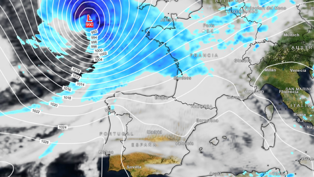
Gales threaten northern Spain as 30C stays possible on the coast: this week's weather splits in two. Credit: MeteoredES / X
People waiting for the first proper cold snap of autumn in Spain are going to have to hold on for a little while longer and won’t be getting it this week, even though the polar jet stream speeds up on Wednesday. Instead, Galicia and the Cantabrian coast brace for gales and giant waves, while the south and the Mediterranean stay surprisingly mild.
The polar jet stream speeds up on Wednesday
From Wednesday October 21, the polar jet stream strengthens over the North Atlantic, according to Meteored’s forecasters.
It will send a deep storm towards western Europe, with its centre expected near the British Isles on Thursday October 22 and a pressure of about 990 hectopascals. Meteored’s Samuel Biener says that centre will cross southern Great Britain and the English Channel, so it’s passing close to home for Brits on both sides of the water.
Despite the name, a stronger polar jet stream doesn’t mean freezing air is heading south from the North Pole. Meteored says it brings high pressure and westerly winds instead, so the thermometers aren’t set to tumble.
Northern Spain takes the worst of the wind and waves
Exposed spots in Galicia and along the Cantabrian coast could see gusts of more than 100km/h, enough to make sailing difficult. The European forecasting model also shows a few isolated waves of 10 metres or more off those coasts as the storm passes close by.
The Basque coast is first in line. AEMET (Spain’s state weather agency) has issued a yellow coastal warning for the Gipuzkoa coast from 3am to noon on Wednesday, for west or north-westerly winds of 50 to 61km/h.
Rain will follow the wind, although not everywhere. It will be heaviest in north-west Galicia and patchier across the rest of the north and the Balearics, while a ridge of high pressure keeps the rest of mainland Spain cloudy but dry.
Cooler air settles over the north while the south stays put
Wednesday starts chilly in the north and centre, with lows of around 5C in Burgos and Valladolid and about 9C in Madrid. Then comes the split. On Thursday and Friday, maximums are forecast at 23C to 25C in Andalucía and 23C to 24C along the Mediterranean, against only 15C to 20C in the north.
That’s a gap of up to 10 degrees between the two halves of the country, and Saturday looks much the same, with similar temperatures in the south and a fresher north. For comparison, Alicante was around 28C on Tuesday, with Valencia and Murcia between 25C and 27C, so the Mediterranean coast loses only a few degrees.
Sevilla and the coast could stay warm into the weekend
AEMET’s own forecast for Sevilla shows 25C on Wednesday, 27C on Thursday and 26C on Friday and Saturday, with Sunday the warmest day of the week at 29C and only a 10 per cent chance of rain. Those figures sit a little above the 23C to 25C Meteored gives for Andalucía overall.
On the coast, Biener says some Mediterranean spots could touch 29C or 30C on Tuesday, and match or beat that by the end of the week on days when the poniente (the warm, dry westerly wind) blows.
Flood-hit Valencia and Alicante get a break from the rain
Residents still recovering from the DANA Adam will welcome that. It dropped more than 700 litres per square metre in about 36 hours at weather stations in Pego and l’Atzúbia in Alicante province, and has left at least five people dead, according to first tallies. Cataluña’s civil protection service has now lifted its flood alert.
Meteored doesn’t expect any widespread rain in the short or medium term, although it warns forecasts can change quickly at this time of year. Waterlogged ground is the worry, as it said on Monday that any fresh rain could make flooding worse.
Canarias stays out of the storm’s path
The Canary Islands miss out on the rain too. The jet stream is speeding up rather than dipping south, which keeps storms well to the north and leaves fewer chances of rain on the islands.
AEMET expects little change in temperatures on Thursday, with only occasional rain in the south and west of the interior and light dust haze (calima) high up over the eastern islands. Further ahead, its seasonal outlook gives a 60 to 70 per cent chance of a warmer-than-normal three months, with just a 25 per cent chance of above-average rain.
Forecasters don’t all agree on how far the cold reaches
Not every forecaster is as relaxed about the weekend. Meteorologist Mercedes Martín has pointed to falls of more than 10C in parts of the interior and north from Friday, while the European model has hinted at an upper-level low that could bring rain to Cataluña, the Comunidad Valenciana, Murcia and Andalucía. AEMET, meanwhile, expects little rain across most of the country this week.
Nobody is forecasting a lasting cold spell, though. AEMET still rates October 19 to 25 as warmer than normal for most of Spain, coming after the warmest September on record, and expects the whole autumn to run warm.
With the exact track of the storm still able to shift, anyone planning a trip along the north coast, or between Spain and the UK, should check AEMET’s warnings again before setting off.
Follow Euro Weekly News on Google News
Get breaking news from Spain, travel updates, and expat stories directly on your Google News feed.
Follow on Google NewsSign up for personalised news
Subscribe to our Euro Weekly News alerts to get the latest stories into your inbox!
By signing up, you will create a Euro Weekly News account if you don't already have one. Review our Privacy Policy for more information about our privacy practices.





Harry Dennis
Born in the UK and raised on the Cádiz coast, Harry brings his background in design, music, and photography to his writing for Euro Weekly News, sharing stories that celebrate culture and lifestyle across Spain and beyond.
Comments